The Bob Graham Round
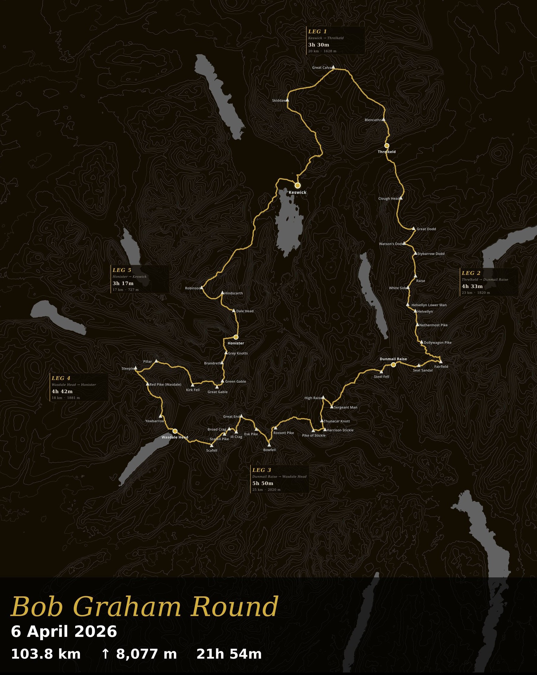
42 fells, 104km, 8,000m of climbing, a continuous loop from the Moot Hall in Keswick and back inside 24 hours. That’s the Bob Graham Round. I went round on 6 April and finished in 21 hours and 55 minutes.
The map above is the GPS track from the day, drawn over the Lakeland fells the round visits. One picture, one line, the whole thing.
If you’ve done a round, or are planning one, and want a map of your own line on the fells, get in touch and I’ll put a draft together for you. Custom styles and tweaks are available.
The Round
The Bob Graham Round was first completed by Bob Graham himself in 1932. The challenge has stayed almost exactly the same since: start and finish at the Moot Hall in Keswick, take in the 42 named fells, do it inside 24 hours.
If you’re interested in the history of the round, the Bob Graham website has a great write-up of the story and how the challenge has evolved over time. The same site also has a schedule calculator, which is a great tool for planning your own round.
I went clockwise, setting off from the Moot Hall at 02:40 on the morning of 6 April and getting back at 00:35 on 7 April.
The Day
Leg 1, Keswick to Threlkeld. Skiddaw, Great Calva, Blencathra. This went well. Warm enough, moved efficiently in the dark having previously done this leg in January. The bog at the bottom of Skiddaw slowed me in head-torch light, but not by much. I reached Blencathra slightly ahead of schedule, which meant starting Halls Fell with less light than I’d ideally have liked. Still went much better than January when it was covered in ice.
Leg 2, Threlkeld to Dunmail Raise. Hard. Colder, windier, zero visibility. Fortunately Oscar was with me for the leg and made the difference both for navigation and for keeping me moving. I’d overeaten at the Threlkeld stop, a theme that would come back to bite me later, and felt sick most of the way over the Dodds and the Helvellyn ridge. This was the closest I came to packing it in.
Leg 3, Dunmail Raise to Wasdale Head. A bacon sandwich at Dunmail helped, although I didn’t eat quite enough at the stop and didn’t put enough snacks in the vest, something I only twigged around Bowfell. The weather was clearing and warming up. I’d run legs 3 and 4 together two weeks earlier at the right sort of pace, so the ground felt familiar. The sun was finally out by the Langdale Pikes. I went knee-deep in the bog on Martcrag Moor and got mildly lost on the Climber’s Traverse, having followed the line cleanly on the recce. Didn’t concentrate enough and ended up too low. By the top of Bowfell I was rationing food, having figured out my mistakes. Despite all that I was still moving well, which mattered as Broad Stand approached. Broad Stand itself went fine, wetter than on the recce. Coming off Scafell I tried one of the suggested gullies I’d missed last time, which was a silly call and slowed me down. Arrived in Wasdale starving but more confident about finishing in time.
Leg 4, Wasdale Head to Honister. Decent feed at Wasdale, repacked the vest properly, and a quick chat about the climb out. My dad had been warned by someone that Yewbarrow is where rounds die. I was looking forward to this leg as on the recce I’d made up lots of time on the big climbs. This theme repeated itself and I made it to the Great Gable descent before dark. Darkness arrived eventually and slowed my route-finding into Honister, but by then I was becoming quietly confident of finishing. Leg 4 was the leg I enjoyed most.
Leg 5, Honister to Keswick. Overate again at Honister and felt sick for it. Lauren joined me for the final leg, which was needed. I walked most of the three remaining tops and Lauren scouted the awkward descent off Robinson. Still nauseous, I was trotting very slowly along the road before some sugary jelly snakes from Lidl perked me up enough to pick the pace up and run it in to Keswick. 21 hours and 55 minutes on the Moot Hall steps.
The Support
The round was supported almost entirely by family. JJ at the first stop. Oscar ran leg 2. Hannah, James and Nathan supported at the second stop. My dad supported at stops 3 and 4. Lauren ran leg 5. Both of the legs I had a pacer on were legs I hadn’t run before, and the navigation help made all the difference on leg 2 in particular. The round wouldn’t have been possible without any of them.
Kit, Pacing, and What Worked
I was aiming for a 22.5-hour schedule, with a quiet hope of clawing back enough later on for a sub-22. Thanks to the Bob Graham website schedule calculator for making the planning side of that straightforward.
I knew I’d get wet feet on leg 1, so I changed shoes and socks at the first stop and ran the rest of the day in my trusty Salomon Speedcross 4s, swapping socks at each stop after that.
Fuelling was the weak point. Overeating at stops left me feeling sick for legs 2 and 5 therefore not eating enough on the go. Then under-packing the vest on leg 3 left me rationing snacks across Bowfell, Scafell Pike and Scafell. If I were doing it again, the obvious lesson is smaller portions at the stops and properly packed snacks before leaving each one. Everything else more or less held together.
The Map
The line on the map above is the GPS track from the day, exported from my watch and drawn over the fells. No retouching, no idealised route. It’s the actual line I took, including the bits where I went the long way round.
The map is the physical thing I came away with that captures the whole round in one go. MunroMapping is the tool I built to make maps like this from Strava data, originally for the Munros and Wainwrights. The Bob Graham render is the same idea, applied to one very long day in the Lakes.
Thanks
To JJ, Oscar, Hannah, James, Nathan, my dad, and Lauren. Round wouldn’t have happened without you.
Related posts
Wainwright Completion Gifts — Ideas for Someone Who's Finished All 214
A personalised Wainwright map of every GPS-recorded walk across all 214 fells is a lasting Wainwright completion gift, a record of years of Lakeland weekends.
Bob Graham Round Completion Gifts — What to Buy Someone Who's Just Done It
A map of their actual round from GPS data is the Bob Graham Round completion gift that captures the day itself, every fell, every leg, their specific line.
Plan Your Next Hill Day with the MunroMapping Route Planner
A free interactive route planning tool built for Scottish hillwalkers and Lake District fell runners.
Ready to create your own map?
Connect your Strava account and generate beautiful, personalized maps of your hillwalking achievements.
Get Started Free